The Freezing Winter 2009-10 does not mean that Global Warming is not happening
During December 2009 and January 2010 we experienced some harsh winter weather across the UK, Northern Europe, China and central USA. However, this is not evidence that there is now some doubt in the global warming trend. It is important to notice that during this winter, other parts of the world were a lot warmer than normal (for example in Greece and Alaska).
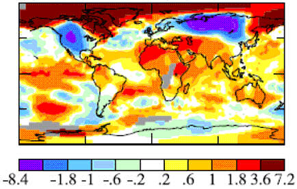
What we experienced was an example of the wide range of natural variation that we can always expect in our local, day-to-day weather. The following map shows how the temperature varied from local averages across the world in December. Notice that whilst in Siberia the monthly average was 8ºC lower than normal, in Alaska it was about 7ºC higher!

The map is taken from "If It's That Warm, How Come It's So Darned Cold? An Essay on Regional Cold Anomalies within Near-Record Global Temperature" by Hansen et al [2010]. ![The temperature anomaly is presumably compared to the 1951-80 period used by the GISS model. [i]](../images/_info.jpg)
We will obviously have to wait for a few months before temperature data is available and has been analysed for the whole of this winter. It is looking like hot temperatures in other parts of the world more than compensated for the cold weather that we experienced: figures from the National Oceanic and Atmospheric Administration (NOAA) rank December 2009 as the 8th warmest on record, and January 2010 as 4th warmest ![The period of record is from 1880-2009. [i]](../images/_info.jpg) .
.
There are estimates in for the year 2009: Hanson et al [2010] make it the joint-second warmest on record (with the southern hemisphere actually being reported as the warmest on record); whereas the National Oceanic and Atmospheric Administration (NOAA) estimate it to be the fifth warmest on record. ![The difference between the estimates comes for different global averaging techniques: whether it was rank 3 or rank 5 it is still right at the top of the 130 year record! [i]](../images/_info.jpg)
Why it was so cold for us this winter
In the UK, our weather is very sensitive to the position of the Polar Front Jet Stream This forms a band around the mid latitudes where cold northern air meets warm air moving up from the tropics. When it runs across the country, we can expect days of rain as weather systems tend to track along it from the Atlantic. When it loops well to the north of Scotland, we can expect dry, anticyclonic weather (hot, sunny days in the summer; cool, frosty days in the winter).
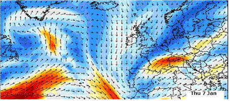
The winter of 2009-10 was exceptionally cold because the Jet Stream was unusually weak, and looped far to the south of the UK. This loop of cold, polar air, stretched as far south as Spain, which you can see from the following map of wind speed and direction (from to main www.metcheck.com). Notice that meteorologists look at wind patterns at about 12 kilometres (40,000 ft) above the ground ![Meteorologists actually look at wind speed / direction at heights of equal pressure. In this case they look at the 200 to 300 millibar (mb) height, which is around 12,000 metres above the ground. [i]](../images/_info.jpg) to try and estimate the position of the Jet.
to try and estimate the position of the Jet.

On the other side of the Jet Stream, parts of the south east Europe were experiencing notably high temperatures. In fact the Greek island of Crete recorded temperatures of 30ºC New Year's Day 2010, which was the highest temperature ever recorded in Europe in January (recorded at the Vrysses weather station in Chania and noticed in this article in the Guardian). And Bethel in Alaska experienced a "Brown Christmas", with unseasonably warm temperatures of about 0ºC. ![For example, here is comment posted by 'frogbandit' at 8:38p.m. 1/6/2010 on http://blog.seattlepi.com/robertbrown/archives/190211.asp: '...I hear people down in the lower 48 say its really cold this winter. That ain't true so far up here in Alaska. Bethel, Alaska, had a brown Christmas. Here in Anchorage, the temperature today is 31[degF]...' [i]](../images/_info.jpg)
.jpg)
Return to main About Climate Change page

![link to W3C validation website, which will show that the stylesheets are Valid CSS [css]](http://jigsaw.w3.org/css-validator/images/vcss-blue)
![link to information about this website [info]](../images/btn_info.jpg)
![jump up to the top of this page [top]](../images/btn_top.jpg)